")
")
")
The Via Belgica was devised by Julius Caesar around 50 BCE, following his conquest of Gaul. Incorporating several traditional but unpaved routes, Caesar sought to secure the free movement of legions along the expanse of Gaul from the Northwestern coast of France to Germania Superior. However, the task fell to Augustus following Caesar’s assassination. He expanded and extended these preexisting roads with small slab stones to create the Via Belgica. One noted feature of the Via Belgica is that it was not surveyed in Roman miles but the leugae of the original paths. But, Roman milestones do exist and are predominate between Maastricht and Cologne.
With the creation of the road came the establishment of Roman settlements along with it. Several of these can be viewed on the Peutinger Map (a portion is visible in the photo gallery above). This map is based on one sponsored by Agrippa, Augustus’s close friend and son-in-law, and the sponsor of the massive map of the known world during the reign of his friend. This map has allowed historians to follow the expansion of Roman settlements in the area.
Watch archaeologists discuss the Roman remnants along the South Limburg portion of the Via Belgica (in Dutch with Auto-Translate closed captioning available):
The Via Belgica was intersected by local roads, like spokes on a wheel jutting out from the main course at the site of major cities along its route. These routes helped not only to facilitate the movement of the army but also stimulated trade on a much larger scale than that which the region had previously pursued.
The road begins at Amiens and continues to Cologne. It was strategic brilliance that Julius Caesar established this road connecting the region as it had proven difficult historically to get supplies to the army within Gaul. With the road constructed, supplies could be shipped along the coast of Europe to Amiens to enter the transport line. In addition, wheat and barley from the Eastern region of Germania could now be shipped via the Rhine or Maas before heading overland. Without the road, Julius Caesar might not have been able to hold his conquered province, and Claudius might not have been able to add Britannia to his Empire.
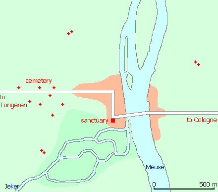
Roman environs of Maastricht showing its orientation with Tongeren and sites of excavated Roman necropoli along the via Belgica road. The sanctuary is the site of the Jupiter sanctuary, at the site of the Vrijthof in Maastricht. (Image credit: Jona Lendering, Source: Livius.org, CC0 1.0 Universal)
As Germania became firmly established as a part of the Roman Empire, some familiar buildings would greet travelers along each leg of the road. An astonishing number of villae have been excavated in the Low Countries in recent decades. Cemeteries dotted the road just on the outskirts of the towns. And Roman inns were evenly scattered along its route, as well as pillars dedicated to Jupiter beside roadside shrines.
After the fall of the Roman Empire, the roads continued to be used but fell into disrepair. As the economy and agriculture became more localized, and safety again became a primary concern along the unpatrolled road, the great Roman Via Belgica was reduced to yet again a system of well-worn paths.
Portions of the road can still be found throughout Maastricht’s county of South Limburg. Some no longer contain the Roman paving, while other portions have been uncovered through trial trenching.
Watch archaeologists, geologists, surveyors, and other experts tour Roman tributes to gods and funerary commemoration along the Via Belgica (in Dutch with Auto-Translate closed captioning available):
Find Your Way
Roman South Limburg Guide (in Dutch) Available at bol.com
Published February 2019
In this 188-page guide, you will become acquainted with a South Limburg that you do not know yet. Discover the extensive Roman heritage through walking routes, stories, recipes and essays about Roman South Limburg.
A long-distance walk and eight detours, with a map and detailed directions, bring the Roman past back to life. On the way, enjoy the impressive views of the landscape as the Romans left it for us.
Exclusive to this guide are eight tasty recipes that have been developed by regional chefs. They have been inspired by Roman cuisine and the local products and crops that the Romans once introduced to South Limburg. In addition, there is room for background and reflection. Journalistic essays make the link between present and past and offer depth on the themes of archeology, food, innovation, architecture, culture, and landscape.
Visit Nearby
This museum as a collection of Roman artifacts found along the Via Belgica in South Limburg (14 km).